Our RV trip to the western part of the US took us along I-40. Along the way we stayed at a few roadside RV parks. One, in Morrilton, Arkansas, was particularly sketchy, but then Larry was unimpressed by most of I-40 through Arkansas, especially the rough highway in the eastern section. Rest Areas between Tennessee and New Mexico were also in short supply. At least half of the existing ones were closed for repairs or upgrading. It was a relief when we finally arrived at our first major stopping point in Gallup, NM.
USA RV Park was a beautiful and welcome stop.
Just across the border in Arizona is the Painted Desert and Petrified Forest. We took off the next morning and drove about an hour to the entrance for both parks. The road starts by taking you through the southern corner of the Painted Desert, then turns south and continues through the Petrified Forest. As with the other places we have visited, the drive through isn't long, but the pull-offs for viewing vistas, and trails you can take, mean you can spend quite a bit of time there.
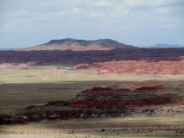
The Painted Desert is a landscape of distant flat plateaus, and buttes, and up-close rounded dunes in shades of pink, coral, rust and cream. It is the palette of the southwest. We will see these colors for the next couple of weeks as we explore other parks. The landscape itself is just a hint of what is to come. Muted and subdued, it eases our adjustment from flat and dry to what is soon to become spectacular canyons and colors.
We left the Painted Desert and continued on through the Petrified Forest.
When I was a little girl, I envisioned a forest that one could walk through, of tall, stately trees. I would have been confused by the term 'forest' for what resembled the left overs after a lumber company had cleared a hillside. By now, I knew that wasn't the case, but the 20 minute video in the Visitor's Center really helped me understand the story behind the forest. In a nutshell, (and with little geological background), in the Late Triassic period the trees once did stand tall. The climate was tropical. Trees that had fallen in river and stream beds were often covered in silt containing volcanic ash. The silica in the ash replaced much of the original wood, but retained the cell structure so the trees themselves became rock containing quartz structures.
Petrified wood can be found in all 50 states. This place just has a large concentration of it and therefore has been set aside as a place to study, explore, and leave untouched.
The Petrified Forest also exposes life from those that followed the Triassic period.There were several places where we could see petroglyphs, an ancient form of communication, that has stood the test of time.
Petroglyphs are pictures carved into the rock, using a stone chisel, that early peoples used to communicate. They may be a way of communicating a great warrior's accomplishments, or signs that many people traveled through an area. Some petroglyphs may be a sign of stair steps, climbing or just a decoration, like the ones pictured below.
 |
| There are 2 Petroglyphs in the top left of the darkest part of the rock, (Just upper left of center) |
 |
Bird holding a frog. Was this a good place to fish?
|
Other Petroglyphs give us a fascinating glimpse of a smart, scientifically aware people. I was fascinated when I learned that the Anasazi (ancient Indians, called "old ones") had determined the equinox and marked it to track the growing season. It was marked with a square petroglyph on a rock. They could track the progression of summer as a shaft of light reached down between two rocks until it reached the mark on the rock. That was the middle of the year, or the equinox, as we know it.
 |
| This is the Equinox Rock. The petroglyph that marks it is hard to see, but was visible from a distance. |
 |
| The square with the C in the middle that looks like a 'copyright' symbol is the Equinox mark. |
 |
| This diagram illustrates the progression of the sun on the rock. |
We think of ourselves as a superior culture, and it's true, we have gone to the moon. But these people knew the world they lived in better than the majority of those of us inhabiting this same world, today. Amazing!
There were fields with chunks of logs lying on the ground that looked as if a chain saw had been taken to them, (reinforcing my image of a pre-historic lumber company clearing the land).
Today, there are places with lots of log segments lying on the ground.
It is estimated that many trees still remain buried and in some places you can see them sticking out of the ground at your feet, or in cliff edges many feet below the surface.
 |
| Look Closely! There is a log sticking out of the rock just to the left of center in this photo. |
I always felt a bit like an explorer when I walked down a path and saw a piece of petrified tree log sticking out of the hillside or laying off the beaten path.
It was a neat place to go and see prehistoric history.
Along with the pre-historic world, there were signs of a more modern time. The famous Route 66 once traveled through this area before the land was designated as a national park in 1962.
 |
| This car stands as a monument to Route 66 |
Further back than that it was a stagecoach stop on the way west.
 |
| The original stagecoach stop has been rebuilt on the original site. |
And before that we find evidence of inhabitants moving into the region 8,000 years ago.
 |
| Ruins of a Pueblo Village |
This was our first introduction to the history and development of the Anasazi (or ancient peoples that later became the Pueblo people), but not the last. This was their land and we are now the explorers on it.


No comments:
Post a Comment